Glacier's Story

Millions of years ago, the area of the Rocky Mountains was a sea bed. Today, torn red rock appears throughout the mountains, at high altitudes. It is argillite, saturated with minerals and salts, and it is used by goats and others as a salt lick. They load up on the minerals before winter sets in. It is green when it is freshly broken, and then oxidation turns it red.
In the early 1900’s, Charles Bird Grinell was an editor at Forest & Stream Magazine (later Field & Stream). He was an explorer, hiker, and a conservationist with a powerful ally: Teddy Roosevelt. He was, however, no relation to Lady Bird Johnson.
After exploring the northwestern area of Montana, he was instrumental in having the area named a National Park in 1910. He named most of the mountains here; and Grinell Glacier was named in his honor.
The National Park Service was not established until 1916, so from 1911 to 1916, the U.S. Army was in charge of the park. Fire fighting, enforcement of anti-poaching and criminal laws, and mapping were included in the Army’s charter.
The Continental Divide is the line of mountains and foothills which collectively divide the eastern watershed from the western one. Rain or melting snow on the eastern side of the Continental Divide eventually gets to the Gulf of Mexico and to the Atlantic; the western water goes to the Pacific. Actually, a mountain in Glacier is named Triple Divide, because it also defines the Hudson Bay / Arctic Ocean watershed. King Charles of England (Chuck to us) declared that Canada’s southern border shall include all of the Hudson Bay watershed. We listened to him about as much as we listen to his descendent, Prince Gnarly Charlie, and the Canadian border runs about 50 miles north of here.
Based on Army surveys, a road to cross the park was designed in 1916. It was designed to climb the mountains with numerous switchbacks. After construction of a couple of miles, that approach was abandoned and the area was re-surveyed. Construction was resumed, and the final road has only one switchback, named The Loop, which is a hikers’ rally point not far from Logan Pass, the road’s high point. The road was finished in 1933, because the building season was restricted to June, July, August and September by the snow season.
Indian tradition holds that the Creator built the mountains, and then returned to heaven by walking up the tall mountain which they named “Going to the Sun”. The road was renamed from Cross Park Highway (sounds like the Cross Bronx Expressway, or Long Island’s Cross Island Parkway) to Going-to-the-Sun Highway. In the past 40 years, the word “highway” was changed to “road”.
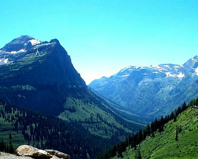
Four ice ages filled the park to depths of 2,500 to 3,500 feet. Glaciers – moving sheets of ice at least 50 acres in size – carved the faces of the mountains as lower areas softened and melted, allowing glaciers to flow down the face of the mountain. If a mountain was carved on two sides by a glacier, it is called an “arête” type; if carved on three faces, the resulting is a distinctive horn shape typical of the Park. A famous example is Europe’s Matterhorn.
Even the trees are interesting. One of the dominant pine trees, Lodge Pole Pines, are very tall and very straight. Their seeds are locked in pine cones which will only open when exposed to heat between 114 °F and 140 °F. The heat melts the pitch in the cone, and the seeds are released. Then, the seeds require unrestricted sunlight to germinate. So, a stand of Lodge Pole Pines indicates that a forest fire once cleared the area.
Oh, and we had a 5.6 earthquake yesterday, but it was received as “ho-hum” – just more nature at work!
Finally, my tour of the park the other day encouraged me that I should overcome my memories of terror when my Dad drove us over the Highway in the 50’s. But, the 21’ length restriction prompted me to measure Big Ride. The truck is 22’-6” long, so I’d have to rent a car. No thanks. When hitched to Big Easy, the 33’ trailer (which measures 35’ overall), the combined length (because they overlap at the back end of the truck) is 53’-6”. Not important for you to know, but I need to remember that!
posted by Greg Finnegan @ 8:56 PM
![]()
![]()


5 Comments:
At 6:15 PM, Mellie Helen said…
Just wait 'til you get to California. Nature loves to "be at work" here!
Or perhaps I shouldn't have reminded you of that...
At 11:20 PM, Greg Finnegan said…
Mellie, we left Glacier Thursday morning, July 28, and should arrive in California on Saturday. We are travelling south to Pocatello, Idaho and Salt Lake City, Nevada, and then west on I-80 to Sacramento / Vacaville.
At 10:11 PM, Unknown said…
I love this post, beautiful and informative.
At 8:43 PM, Mellie Helen said…
I just reread this post, and I feel so relaxed (except for that part about that terrorizing highway -- I hate narrow slivers of road near a cliff's edge). You did a lovely job here of giving us a tour. Thank you, Ranger Greg!
At 4:38 PM, Greg Finnegan said…
Thanks, Brenda. High praise indeed from a wonderful blogger!
Mellie, thatnk you, too, for one who keeps me in awe of your blog.
Lacy and I are now in Sacramento, CA, where it is hot. 90 degrees now, 38% humidity. Low tonight will be 61!
Post a Comment
<< Home